Effective Training with the Utilization of Remote Sensing Applications
R K Gupta, P M Bala Manikavelu, T.S. Prasad and D. Vijayan
National Remote Sensing Agency, Balanagar, Hyderabad
Relevance
Conventional methods in each area of application have error of analysis and if adopting Remote Sensing, GIS and GPS technologies could reduce this range of error, then the new technology becomes meaningful as well as relevant. How accurate the input data should be (from new technology) for a given application objective could be visualized with the example of a practicing doctor. Though technology for measurement of temperature has undergone much advancement (example: consumer goods manufacturing industries), the mercury thermometer of doctor having a least count of 0.1 F has not changed. As after a threshold of 100 F, the medicines (at first prescription) will not get changed even if temperatures is 101 or 102F, may be frequency of dose may increase. Thus 1F is error of analysis with reference to under-standing of human body processes. Thus the Doctor has right for 10 times better input data i.e. 1/10F i.e. 0.1F.Now in conventional measurements based analysis in any application area, if the same data sets are given to say 10 different groups of users, the analysis and recommendation given by these 10 groups would differ widely. This range of variation speaks about the inherent uncertainty in synthesizing and analysis, which speaks about the gray state of skill and knowledge in the particular application discipline. Could use of Remote Sensing, GIS and GPS technologies reduce the uncertainty range and gives input data, which are at least ten times better than error of analysis. The answer would be yes. Requirements for spatial and radiometric resolutions could also be worked out in this manner.
This way the trainee having good subject knowledge and field experience is motivated to overcome the potential barriers with reference to “don’t-know” ( lack of knowledge—cognitive aspect) , “Can’t do” (lack of skill-behavioral aspect). And, the desire/goal to overcome the psychological barrier “won’t do” situation needs to be achieved by practicing affective learning. This motivation is created with exploratory exercises of interpreting a false color composite together with the relevant toposheet after a brief initiation on the first day of training itself.
It has to be made clear that hold on natural happenings cannot be improved by creating more and more data inputs. Improvement comes only by reducing error of analysis. Image form data analysis reduces the range of individual’s variation and makes the process of analysis precise.
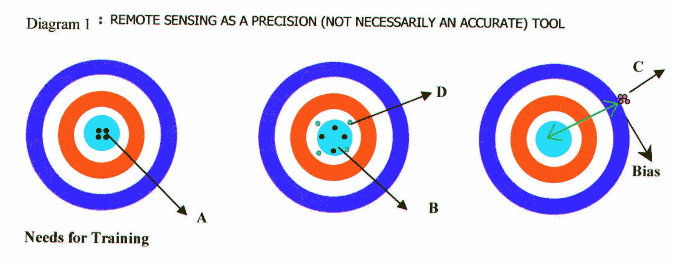
The concept of precision can be explained with the diagram 1. This diagram indicates the three different situations of firing of bullets in a firing range. The shooter ‘B’ is accurate but less precise than ‘A’ and ‘C’. Precision is the capability to repeat the operation and lower the spread of repeated firings more the precision. ‘C’ would have better capabilities to kill a flying bird than ‘B’ provided the gun used by him is mechanically modified by giving offset to viewing/aiming devices as described by bias (a constant appearing in all statistical and mathematical equations). The shooter ‘D’ has no chance of becoming useful. The precision available in Remote Sensing, GIS and GPS technologies is the real strength for getting recognition among scientist working in diversed application areas.
Needs for Training
Having delivered appetizer in the previous section now it is time to go to actual meal.
The application scientists who need training to use Remote Sensing, GIS and GPS technologies pre-dominantly come from Natural Sciences, Social Sciences and Geo-sciences background and a few from Engineering and Physical sciences background. As far as interpretation skills for optical images are concerned we are accustomed to do so right from childhood i.e. in identifying Parents, known persons and even in analyzing their physical expressions under varying moods—-development of intelligence. Thus use of Remote Sensing image by correlating with information base/map from some other source looks very natural. However, intricacies are involved, as interpretation of Remote Sensing image is an ill-posed inverse problem as illustrated below.
The Remote Sensing signal which reaches sensor on-board the Satellite is the complex aggregation of signal (in an agricultural field for example) from soil (with all its variations such as color, texture, particle size, clay content, organic and nutrition content, inorganic content, water content etc.), plant (height, Leaf Area Index, Leaf Inclination etc.), canopy closure status and atmospheric affects; and from this we want to find say, characteristics of vegetation.
The above problem could be illustrated saying a person has six subjects in his university examination with maximum marks as 100 in each subject and only integer marks are allowed (if decimal marks are permitted, the solution will further get complicated). If the total score of the person is 600 then there is only one solution i.e., 100 marks each in all the six subjects. If total score is 599 then there are six possibilities. Had the subjects been 10 then there would be 10 possibilities. Now see how many micro level variables one can create in soil-vegetation-atmosphere system. Here if the total score decreases to 598 and lower, the scope for the number of possible solutions keeps increasing.
Thus, any inverse problem is an ill-defined problem and thus it is not possible to provide a unique answer. Sometimes, during visual interpretation of false color composite of satellite image, one has to give varying interpretation to similar tone and shades using other associated information. Understanding the above mentioned ambiguity needs the association with the experts who have been working in visual interpretation of Remote Sensing images for many many years. A training program provides an opportunity where
deductive and associative approaches could be internalized for interpreting the ambiguities arising out of inverse nature of the problem.
Why is Earthquake predictions and meteorological forecasts difficult? Inverse nature of the problem is one of the reasons.
This also answers why very high classification accuracies are not achievable through computer-based classification. Maximum likelihood is a constraint put to solve the ill-posed inverse problem and for that reason very high accuracies cannot be expected from such modes of working.
To illustrate, if there are ‘n’variables, you need a minimum of ‘n+1’partial differential equations to solve it (in fact, numbers of constants would be more and one would have need for many more partial differential equations). Thus ‘n+1’ independent input measurements are needed and so many bands are not possible under the present status of technology (in future hyperspectral resolution would improve the situation). We do increase the number of possible combinations by having 7 bit/8 bit radiometric resolutions within the current available bands. It is not only the variables but also the large natural variability of the variables which makes the problem more and more complex (to meet deterministic need). One could go to any finer depths in variables by getting into macro, micro, pico——aspects of the process and interactions of the sub-processes; but this keeps increasing the ill-defined/ill-posed aspects of the problem.
Thus there is a need for the programmatic training exposure even for visual interpretation and the need gets exemplified when Digital Analysis Techniques are intended to be exploited—a must for quantitative assessment with assessment of Errors of Commission and Omission.
Do the thematic scientists need to know the physical and technological aspects? This is an often-debated question where the mental convenience of the arguing person overtakes the rationality. Let us see whether the following questions are of interest and use to thematic scientists:
How does a near IR band image of Landsat TM would be different from that of IRS LISS? Which one would be able to discriminate wet and moist soils even in visual interpretation in better manner and why?
Would the Landsat TM NDVI and IRS LISS NDVI show different behavior over irrigated crops?
Why not 2.00-2.35 mm weak water absorption band be used for crop water stress assessment? Similarly, why not the 1.55-1.75 mm band be used for hydrothermal mapping?
Would near IR band be better than thermal IR band to estimate the temperature of Volcano vent?
Why is mid IR better than thermal IR for detecting sub pixel level features?
Why the AVHRR NDVI cannot be compared with IRS LISS NDVI for finer assessment?
NOAA/AVHRR, IRS/LISS and SPOT/MLA are nearly placed at same altitude range. How is it that revisit/review cycles are different for these sensors?
Is restricting of swath width for Earth Resources Satellites a management solution to the technical error
aspects of geometric distortion?
Why Side Looking Airborne Radar (SLAR) is not useful in nadir-looking mode?
How is it that whole of the 3000km swath width AVHRR image useful for meteorology but not in resource management applications? In WiFS data viewed every 5 days for a given field, would the spatial resolution remain same for the target being analyzed?
Why the Remote Sensing Satellites do not pass over the pole and how is this related to the upkeep of sun-synchronous orbit requirements?
One can keep extending the list with reference to how and why aspects of Remote Sensing. Thus discounting the need for knowing Physics of Remote Sensing would be detrimental for the growth of thematic application scientists.
Similarly, the Image Enhancement and Filtering need to be understood with insight of mechanistics. What is physically happening to image under any transformation? How does the change on weightages in a given kernel would impact the image? This will improve the intuitive, innovative and sensible utilization of Digital Analysis Techniques.
Do Principal Components (PC) analysis done on different season images of the same scene can be meaningfully compared? If search is for spectral signature for gold would the PC1 image be useful? How does Kauth-Thomas Transformation differ from the Principal Component Transformation done on the scene predominated with agriculture?
Thus it is necessary that thematic scientists be provided space to think on the how and why of Remote Sensing technology through the conduct of training programs.
There is a need to provide enough time of 11 to 12 weeks so that kinetic energy of mental molecules only generates moderate temperature so that DNA level internalization of Remote Sensing Technology do not degenerate to plastic/breakdown stage. To ensure this involvement, trainees have to be maximized through participative techniques to improve the understanding and retention of discussed matter and trainer has to be very conscious that the lecture delivery does not get degenerated to the state of sustained, passive listening.
Design Considerations
Active training involves three-pronged approach: foreseeing attitudes, developing and practicing skills, and prompting understanding of concepts and models behind the subject.Since too much of training may mask the innovative capacity and capabilities, the duration of 11 to 12-weeks has been taken as the duration for training working level scientists at NRSA, Hyderabad. For decision makers, the earlier conducted 1-week course has been enhanced to 2-week duration to take care of the high inquisitive levels encountered in the past. Custom-tailored courses with specific objectives are designed and conducted at NRSA, Hyderabad.
The Entry-Behavior of course participants is very broad not only thematically but also with reference to
experience and functions. Professional Practitioners in various Government Departments of Central and State (addressing to Landuse, Forestry, Agriculture, Soil, Geology, Geophysics, Groundwater, Water Resources, Integrated Development, Oceanography, Meteorology, Agro-Meteorology etc.), exclusive Photo-Interpretation specialists with high emphasis on Digital Analysis including those who intend to enhance the commercially available software, map-updating professionals, Officers from Non-Governmental Organizations, Scientists and Engineers working in Private Organizations, Faculty and Research students from academic institutes (includes agricultural and traditional Universities) and occasionally from our own sister organizations such as Physical Research Laboratory, Space Applications Centre, Advanced Data Processing Research Institute and ISRO Satellite Centre constitute the profoundly wide spectrum of beneficiaries of training programs conducted at NRSA, Hyderabad.
Thus the design of training program does not assume any prior background in Remote Sensing and takes the trainees to the anticipated future developments for the next 15 years with reference to role of Space Technology in (a) Resource Management, i.e., high spatial and spectral resolution Remote Sensing, and (b) Process Studies (space-based measurements can only provide the simultaneous measurements of various parameters needed for interdisciplinary Geosphere-Hydrosphere-Cryosphere-Biosphere studies in a repetitive manner over the whole globe with same precision/accuracy).
E fforts are made to transfer knowledge in geometric mode to enhance the thinking capabilities and capacity of trainee officers to ensure germination of inspiration for embedding Remote Sensing Technology with the rich experience of trainee officer in a continuous mode during and after training. This teaching mode helps in making trainees capable of growing and deciding themselves with the future changes in the specifications and configuration of sensing systems. This is necessary not only to create competitive human resources but also to work under the recognized facts that the chance of same person coming for retraining is remote and NRSA also has to spread opportunities to newcomers as demand for trained manpower is going to increase in geometric progression.
Though training program is for 11-weeks, it far exceeds the 11-week duration as two field trips are kept on holidays and one of the weekend holidays is for exclusive library consultation to meet the focused need of delivery of a seminar in the topic of utility to the trainee and his/her Organization but also providing global state of the art status in how and why mode.
The 11-week program is partitioned into 8-weeks Knowledge & Skills development module and 3 weeks skill-honing module to do a total interpretation of a small area of the image to get in-depth insights in actual application of Remote Sensing for which expensive Digital Image Analysis and GIS facilities are also made available. Two field experiments in 8 weeks module create understanding of visual interpretation aspects. Here, trainees undergo a group level presentations and thereafter a guided inter-group discussions on what was missed or wrongly interpreted in pre-field visit interpretation and analysis to synthesize the ‘how and why’ aspects of such miscarriages in image interpretations.
Syllabus covered during the 8 weeks module is placed at the Annexure. It covers Physics of Remote Sensing, Aerial Remote Sensing, Satellites and Orbits, Future of Remote Sensing, Overview of applications in all the Application area, over 4? weeks of lectures and guided practicals in Digital Image Analysis and GIS. As trainees need to know how Photoprocessing is done, how the quality of outputs is ensured by NRSA Data Centre (NDC), availability of different photo and digital products from NDC; lectures are arranged from specialists working in Photoprocessing and NDC. Lectures and practicals on Cartography are also included to provide benefit of skills gained by NRSA Cartographers in preparing professional level thematic maps.
To quench the interactions thrust of the trainees and to have the feel of the projects undertaken by thematic experts of NRSA, a 2-day theme-specific sub module is carried out in parallel wherein trainees pertaining to a particular thematic discipline participate. For the 2-week course, the theme specific sub module is of one-day duration.
The genesis for the seminar by each trainee (duly questioned, during delivery, towards optimization by faculty and the course trainees) is based on the premise that each participant brings relevant experience to the classroom. Participants need to be given chance to review what they have learned and blend with the Remote Sensing techniques to achieve precision and reduce the error of analysis of conventional data-based analysis. NRSA library is one of the prime repositories of Remote Sensing knowledge. Developing a thought model by enormous library based explorations (by looking at knowledge spirals witnessed elsewhere in the world) and eye-to-eye contact based discussions on these with diverse group of trainees during seminar presentation creates enhanced positive oriented non-linear growth besides developing self-confidence of the presenting trainee wherein hidden potential gets released. This further reinforces the latent need of what the trainee wanted to learn as the topic of the seminar is selected by the trainee himself/herself. Trainee is suggested to carry with him his view graphs with the request to deliver the same lecture at his sponsor’s place. This also generates feedback to his sponsor besides getting specialized and more meaningful suggestions and comments from peers.
Every day starts with 15 minutes interactive session called ‘feedback’ session wherein doubts of the previous day coverage are cleared. This further helps in fine-tuning with reference to individual needs of trainees besides diffusing the problems while these are in sprouting stage.
Methodology Practiced
Development of trained human resources in interdisciplinary and intensively technology driven area of earth resources management wherein boundaries for the approaches in science and engineering have to be merged with minimum non-linearities and seamlessly with social aspects of management poses challenges not only in the transfer of knowledge through training and education programs but also in developing trainers.Transfer of physics and technical concepts to non-engineering and non-physical sciences background persons demands on transfer of knowledge in geometric and graphical manner (with least involvement of the language of mathematics) to inculcate productive rather than reproductive skills. To achieve the hand-in-hand transfer of knowledge as well as analysis skills, the emphasis has to be on Experiential Learning through Productive Tasks rather than Reception Learning through Reproductive Tasks, which has to be achieved by clearly defining Enabling, Training and Performance objectives for each module.
As seen in diagram 2 (shown on following page), the role of Thinking (as opposed to being told) and trial and error (as opposed to Imitation) is very high in Experiential Learning (as opposed to Reception Learning) .
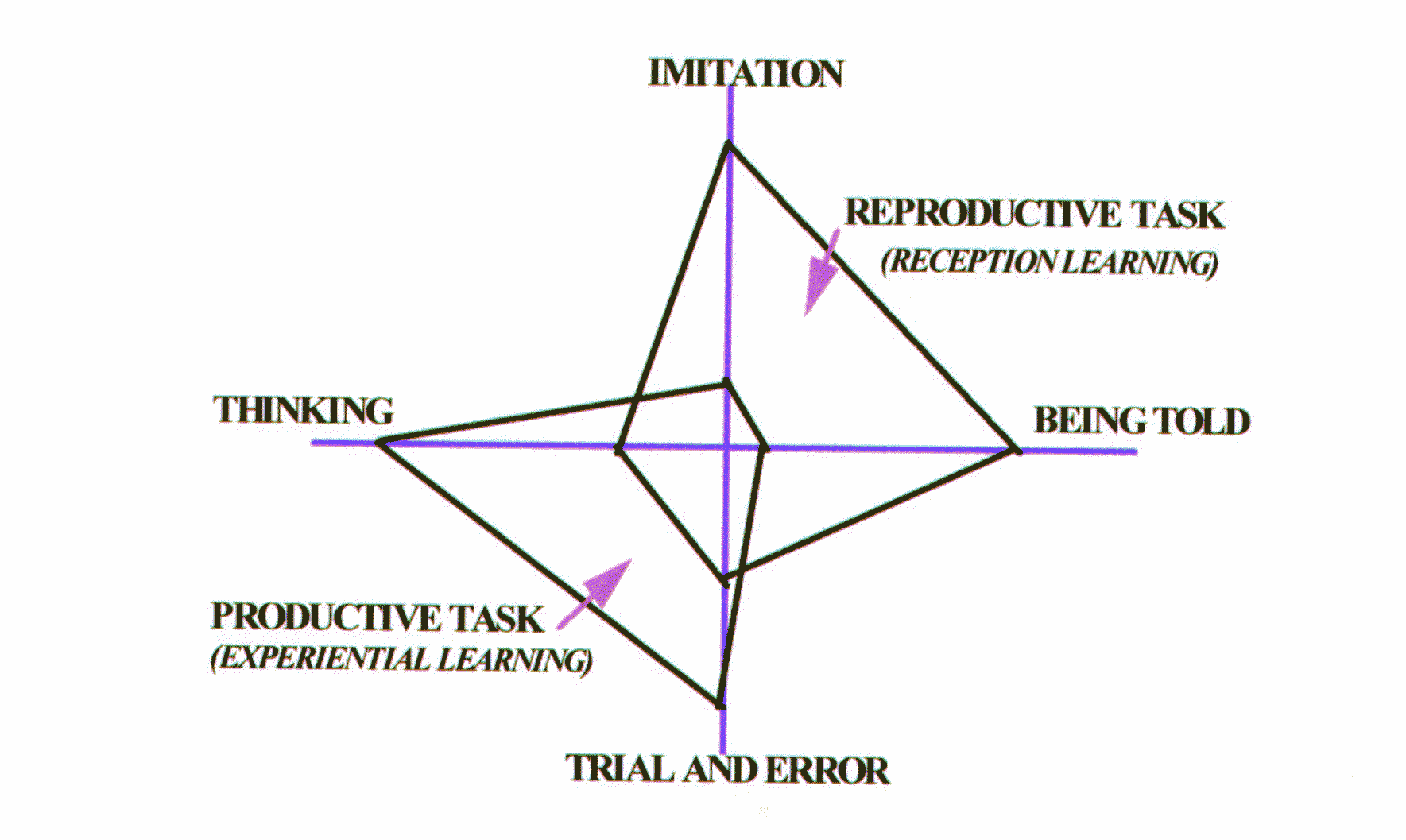
Diagram 2: Illustration of Experimental Vs. Reception learning mechanisms
Experiential Learning sequences involve
Engaging of participants is one or more structured experiences, Sharing of personal reactions and observations concerning the experiences to identify patterns and dynamics that occurred in experiences, Inferring of principals based on what were experiences in real world and thereafter plan for effective behavior in hands-on-module during training and thereafter in real-life tasks.
No matter how well faculty designs a particular activity or presentation, its impact and value may diminish greatly if it is misplaced in overall sequence of events. Following guidelines are adopted for sequencing:
Build interest and introduce new content: set the stage for learning by
using
an activity that hooks participants interest or gives the big picture
Have demanding activities follow easy activities: Get participants
settled in and
warmed up before faculty puts them through hard work
Maintain a good mix of activities: Vary training methods, the length of
activities, the intensity of
activities, the physical setting, and the format. Variety is the spice of good
training.
Teach easier concepts before teaching difficult ones: Generally, one
learns more easily when one idea is an outgrowth of another.
Provide sub-skills before practicing complex skills: Often, difficult
skills cannot be learned
until some basic ones have been mastered.
Close training sequences with a
discussion of “so what”: Have the participants consider the
implications of the course content for themselves.
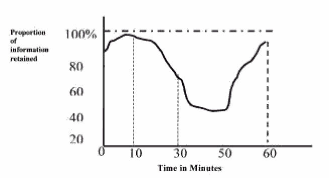
Diagram-3: Schematic Representation of Trainee Retention Capacity.
A trainee can have limited retaining capacity in the short-term memory for 5-30 seconds and thereafter the information is forgotten.
Diagram 3 gives the graph describing the retention capacity of trainees. Here, making lecture in familiar surroundings and introducing in a manner to ensure learning in context could shorten critical period of warming up of mental activity to maximum to 10 minutes.
The diagram 3 indicates that first 30 minutes are most favorable for learning and thus these should be used to present important points. These 30 minutes could be lengthened by
Encouraging active participation Suitable learning environment (e.g.) reasonably cool circulation of fresh air and avoidance of direct sun- light (whole of the training area at NRSA training center is centrally air-conditioned with sun shields on glass panes and additional protection is provided through venetian blinds) Using visual aids and demonstrations Giving handout on major events
Higher retention can be achieved by emphasizing key points, repeating wherever possible and by using visual aids to provide second medium of communication for key points.
To cater to wider and heterogeneous entry behavior of trainees, trainer has to tune the delivery by using the principles of must, should and could (diagram 4). Normally trainer has to practice must (core learning) and should (the possible content which helps to put the learning in context). To satisfy the inquisitiveness of trainees with engineering and physical sciences background, trainer could sometime venture into could (providing of interesting background information). Thus during training there is a need to concentrate on the critical learning areas (Must)—those elements that provide the essential basis on which to build later.

Diagram 4: Discretion cares needed during knowledge transfer
Trainer has to use facts, procedures, concepts and principles for transferring knowledge; and thinking, acting, reacting and interacting mechanisms for transferring skills( Table 1). Here, trainer has to practice following modalities: (1) Start from what is Known to what is Unknown, (2) Start from something Concrete to one that is Abstract, (3) Start from the General and move on to the Particular, (4) Start from Observation and move to Theory, (5) Start with something Simple before making it Complex and (6) Start with an Overview before introducing Details.
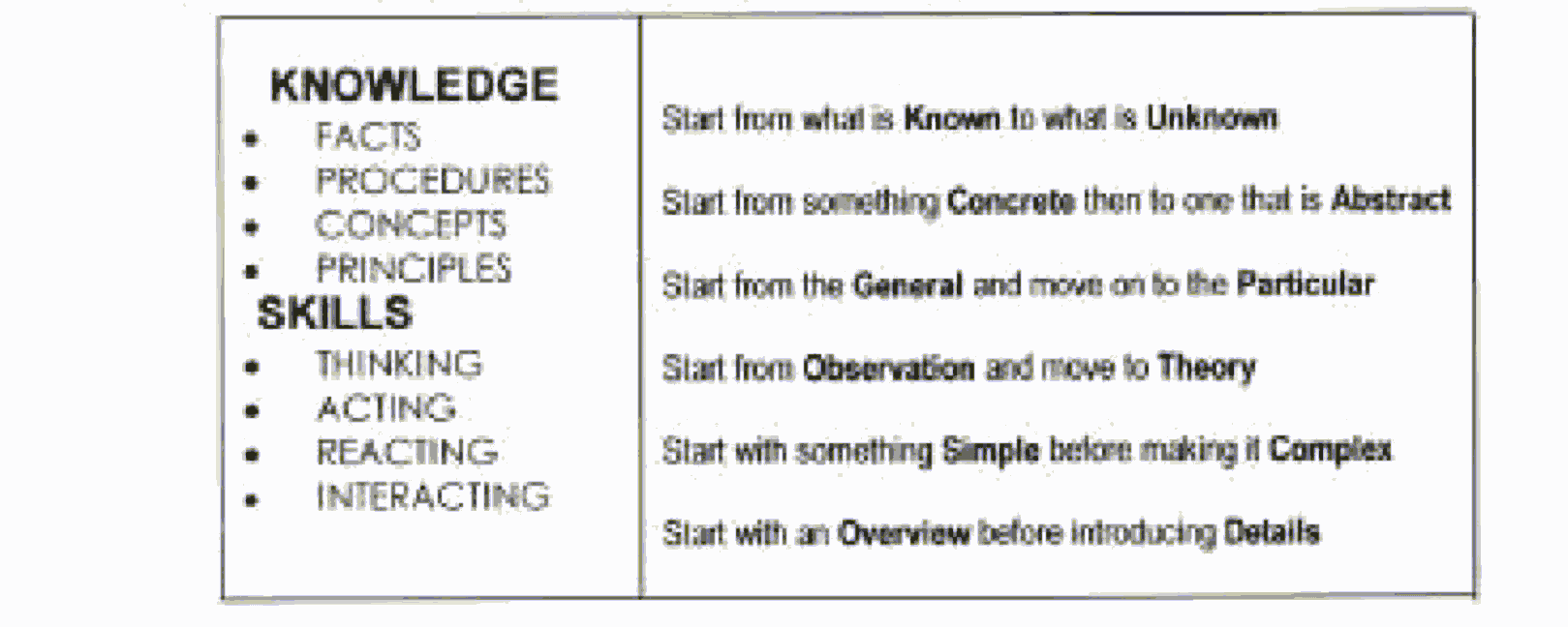
Table 1: Table 1:Modalities for transferring new concepts
The fast emerging technology makes us reach the upper part of sigmoid curve very fast and how to draw another sigmoid curve above the previous one is the continuous challenge for remote sensing oriented peer organizations.
Training Programs at NRSA
Running of training programs at NRSA has been the informal activity till August 1982 and thereafter-regular training programs started taking shape. However, the data about training activities is available from 1985 onwards. As National level projects are handled at NRSA and end-to-end ground segment for remote sensing is available at Hyderabad including user service of generating and supplying data products, there was a need to give benefit of such panoramic exposure by providing training service at Hyderabad.
Training Facilities and Faculty Resources
They include scientists and engineers specialized in their respective fields; engaged in a number of operational projects of national interest, entrusted on them by many user agencies, from the generation of raw aerial data/satellite imagery to the final interpreted and analyzed output products, in almost all the disciplines of applications like Forestry, Geosciences, Water resources, Agriculture and Soils, Land use, Oceanography, Integrated studies etc. Needless to mention about our software expertise in image processing and pattern recognition. Credentials also include publications of multi-discipline and inter-discipline research papers in various international journals in the areas of Image Processing-pattern recognition, Land Surface Processes (LSP) studies, agro–meteorology, hyperspectral analysis, GIS and a few scientists also have been in the editorial board of prominent research journals like International Journal of Remote Sensing. Thus, we are richly endowed with wisdom gained by experience, commanding state-of-the-art knowledge fortified by research too.Facilities at Training and Education Group for the analysis of remote sensing data include state-of-the-art industry standard software and hardware. The labs are equipped with multiple licenses of GIS and Image Processing softwares like ArcInfo, ArcView, GeoMedia, EASI/PACE, ERDAS IMAGINE, ENVI, Matlab and hardware like robust PIII workstation/PC’s (Gateway, Digital, Compaq with Windows 95/98/NT/2000 operating systems) and peripherals like large format scanners for analogue-digital con-version and in B/W and color modes, A0 digitizers, A0-A4 plotter/printers, with ambient working environment.
Training Statistics
Total number of courses conducted during 1985 – mid 2001 are 132 and number of participants trained are 1936 and diagrams 5(a) and 5(b) give the respective pie diagrams giving distribution with reference
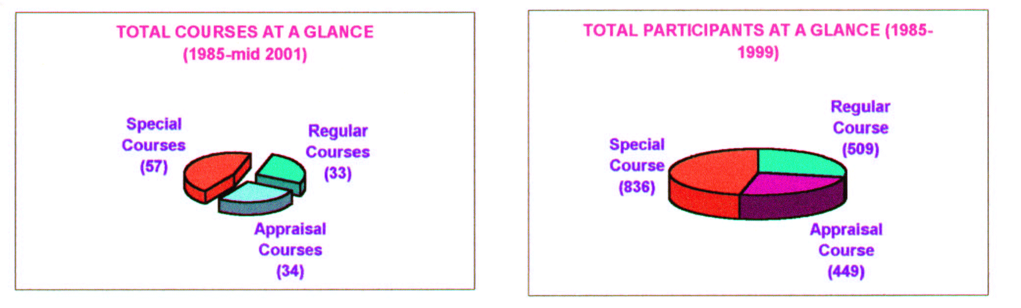
Diagram 5(a) Diagram 5(b)
to regular (8 week, 10 week and 11 week clubbed together), Appraisal (1 and 2 weeks clubbed together) and custom tailored courses which included exclusive GIS, Remote Sensing, Earth Station Maintenance and Image Processing Courses besides the courses addressing to the specific needs of user agencies for using remote sensing technology. Recently a spin-off course for application of image processing techniques in analyzing questioned documents was undertaken, this conveys the openness of NRSA training system in meeting user needs.
Acknowledgements:
The working environment of National Remote Sensing Agency, Hyderabad and interaction with trainees had been responsible to evolve the thought process presented in this paper, authors are grateful to them.BWW Society Member Dr. Rajendra Kumar Gupta received his Ph.D. degree in Physics in 1991 from Jawaharlal Nehru Technological University. He is a Fellow of the Andhra Pradesh Akademi of Sciences, and the Institute of Electronics and Telecommunications Engineers, and the Editor of the International Journal of Remote Sensing (Taylor & Francis, United Kingdom). Dr. Gupta has also edited and co-edit ed recent editions of Advances in Space Research (United Kingdom).
[ BWW Society Home Page ]
© 2002 The BWW Society/The Institute for the Advancement of Positive Global Solutions